|
Extracted
from the Traveler's Ecuador Companion © The
Globe Pequot Press. Reproduced with permission.
Photos
by Dominic Hamilton.
AROUND QUITO
King of the national parks near Quito
is Cotopaxi. Access is pretty straightforward from the
two entrances off the Panamericana, or else every adventure
tour operator worth its salt in Quito offers transport and/or
guides to the park. You can enjoy both short hikes around the
refuge, or longer trails to Volcán Rumiñahui,
for example. If you're lucky you might spot a condor or herds
of wild bulls or horses, even a mountain lion. Parts of the
park are so remote that you can camp there for a week and not
see one other person. Also
popular close by is hiking in the shadow of the two Ilinizas
volcanoes.
Close to Quito itself, you can hike up both Rucu and Guagua
Pichincha. The best access to the latter is from the pretty
town of Lloa, reachable by bus from the capital.
AROUND OTAVALO
North of Quito, possibilities abound. Around Otavalo, you can
hike round the Laguna Mojanda or the Lago de San Pablo
in a day, passing through lots of villages on the latter
circuit.
Also enjoyable is hiking around the Laguna Cuicocha,
further to the northwest, part of the enormous Cotocachi-Cayapas
Ecological Reserve.
Further west from here, the Intag
Cloud Forest Reserve, in the vicinity of Apuela, has basic
accommodation and great trails. Nearby is the Bosque Nublado
de Santo Tomás. For more information on these, contact Safari Tours (022) 552505 or 223381 fax (022) 220426
e-mail admin@safari.com.ec
web site www.safari.com.ec,
Calamá 380 and Juan León Mera, Quito.
AROUND IBARRA
Heading up to Ibarra, the best access to Volcán Imbabura is from the small hamlet of La Esperanza, where you
can base yourself at one of the friendly, family-run hosterías.
Further
north still, there are some great trails up to the haunting
Páramo El Angel close to Tulcán on
the Colombian border. Fundación Golondrinas, an
Ecuadorian NGO, is active in conservation work in the area and
organiteles treks from the village of El Angel up to the páramo.
For details contact Piet Sabbe, Cerro Golondrinas Project Coordinator
(022) 226602 fax (022) 566076 e-mail manteca@uio.satnet.net
.
CONDOR TREK
One of the most popular, demanding treks south of the capital
is the Trek of the Condor. It begins at the village of
El Tambo, close to the Papallacta springs, crossing the Antisana
Ecological Reserve between the two peaks of Antisanilla and
Antisana, before following various streams all the way down
to Cotopaxi National Park. It takes three to four days to complete.
 QUILOTOA AND TIGUA QUILOTOA AND TIGUA
Further south of Quito, basing yourself at the Black
Sheep Inn, the owners can point you in the right direction
for many hikes in the stunning Quilotoa/Tigua region.
The trek up, and round if you wish, to lake of Quilotoa is probably
the most raved about.
 BAÑOS BAÑOS
Around the popular spa-town of Baños there are
many trails to villages, ranging from the day-hike to great
viewpoints, or longer four-dayers. Hikes up to Volcán
Tungurahua, inside Parque Nacional Sangay, may or may not be
off-limits when you read this. For excellent guides to Sangay,
contact Alta Montaña in Riobamba (03) 963694 fax
(03) 942215 or in Quito tel/fax (022) 504773, Jorge Washington
425 and 6 de Diciembre, e-mail aventurag@laserinter.net
.
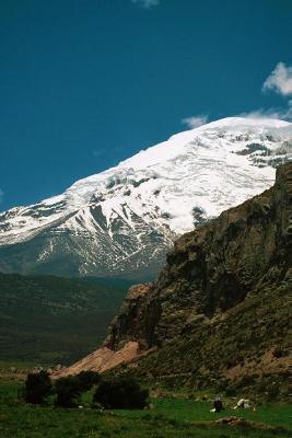
CHIMBORAZO
Riobamba is the natural spring-board for hiking around
both the mammoth Chimborazo and the spiky El Altar
volcanoes. For the former, contact the community-based project
of Pulingue San Pablo (or 'Waman Way') (03) 949510 or
949511 e-mail waman_way@hotmail.com
(Spanish only) on the road up to the refuge. You can stay in
simple cabins nearby. For more information contact Tom Walsh
e-mail twalsh@ch.pro.ec
ECUADOR'S INCA TRAIL
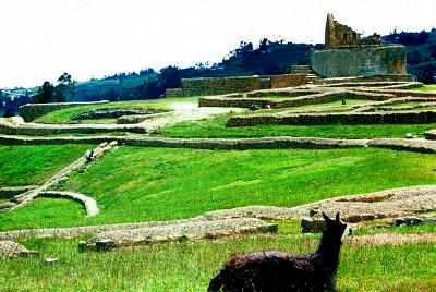 Not to be outdone by Peru (it is in most other things...), Ecuador
has its own Inca Trail. The three-day trek begins at
Achupallas, some 25 km (15 miles) from Alausí
on the Panamericana (south of Riobamba). The best day to start
the trek is Saturday, when you can stock up on food at the market
of Achupallas. The trek climbs to some 4,000 m (13,120 ft),
passes various lakes great for camping, as well as parts of
the old Inca cobbles, and finally reaches the Inca ruins of
Ingapirca, and the town of the same name. Not to be outdone by Peru (it is in most other things...), Ecuador
has its own Inca Trail. The three-day trek begins at
Achupallas, some 25 km (15 miles) from Alausí
on the Panamericana (south of Riobamba). The best day to start
the trek is Saturday, when you can stock up on food at the market
of Achupallas. The trek climbs to some 4,000 m (13,120 ft),
passes various lakes great for camping, as well as parts of
the old Inca cobbles, and finally reaches the Inca ruins of
Ingapirca, and the town of the same name.
SOUTHERN HIGHLANDS
From the capital of the southern highlands, Cuenca, the
most popular hikes explore the wild, cloudy and cold expanses
of Cajas National Park. There are plenty of rivers, lakes
and stunted forests, as well as stunning hummingbirds. Access
to the park is straightforward by bus, and for guides you can
contact various competent tour operators in the city.
In the very south of the country, both Loja and Vilcabamba
offer good access to the much-lauded Podocarpus National
Park. From Loja, the bus can drop you off close to the entrance
to the park, from where you proceed to the first refuge.
Good
information in Loja is available from the Ministerio del
Ambiente headquarters tel (07) 563131 on Sucre between Imbabura
and Quito, and from the Fundación Ecológica
Arcoiris tel (07) 577449 e-mail fai1@fai.org.ec
, on Segundo Cueva Celi 03-15. Recommended tour operator include
Biotours TEL/fax (07) 578398 e-mail biotours@loja.telconet.net on Colón and Sucre, and Aratinga Aventuras Birdwatchers
TEL/fax (07) 582434 e-mail jatavent@cue.satnet.net , on Lourdes between Sucre and Bolívar.
For guides from
Vilcabamba, contact Orlando Falco of the Rumi Wilco Ecolodge
and Nature Reserve (no phone) e-mail ofalcoecolodge@yahoo.com,
or Charlie and Sarah of Cabañas Río Yambala (no phone) e-mail rio_yambala@yahoo.com or yambala@impsat.net.ec web site www.vilcabamba.cwc.net .
EASTERN FOOTHILLS
On the eastern side of the Andes, there are some great hikes
to be enjoyed around Baeza and the San Rafael Falls,
very popular with birdwatchers, and there are some tough treks
back up into the Andes from Puyo, Tena and Macas which can be
arranged with local tour operators. In the Oriente itself, independent
trekking is discouraged by the local Indians, and you should
join a tour, preferably an indigenous-run one, for exciting
hikes through the jungle, canoe trips down rivers and encounters
with local communities.Heading down towards the coast, many
people stop in the Mindo and surrounding area for some great
trails through dripping, epiphyte-clad cloudforests. The best
way to enjoy these is to stay at one of the lodges.
COAST
 On
the coast itself, the most popular hikes are in and around Parque
Nacional Machalilla, where you can find guides in the local
villages to explore the dry and lower reaches of cloud forest.
Operators in Puerto López can help with practicalities. On
the coast itself, the most popular hikes are in and around Parque
Nacional Machalilla, where you can find guides in the local
villages to explore the dry and lower reaches of cloud forest.
Operators in Puerto López can help with practicalities.
Further north, in Bahía de Caráquez, contact Guacamayo
Bahíatours TEL (05) 690597 fax (05) 691412
e-mail ecopapel@ecuadorexplorer.com
web site www.qni.com/mj/riomuchacho , Avenida Bolívar and Arenas, for information about the
great Río Muchacho area.
In the south, contact Fundación Pro-Bosque TEL (04) 416975 or 417004,
Edificio Promocentro, Cuenca and Eloy Alfaro, in Guayaquil,
for more information about the park and guided tours in the Bosque Protector Cerro Blanco, or other reserves close
to the city .
PRACTICAL INFORMATION
Most people's first port of call are
the national parks and reserves which ring Quito. It's important
to remember that even if you're not attempting to summit a peak,
you should acclimatize before attempting long hikes at high
altitude. Spend a few days in Quito before hitting the hills,
and drink water like the clappers when you're on them. Sunburn
and harsh conditions can also be a problem, so come well prepared.
There are plenty of outdoor outfitters in the Mariscal area
if you've forgotten to bring anything. On anything but rocky
terrain, I would recommend investing all of $10 in a pair of
rubber boots. Not the height of fashion next to your $100-turbo-goretex-latest-purchase,
but tried-and-tested by highland villagers throughout the country!
Although
in some parks (Cotopaxi, for example) or on popular routes (up
Imbabura, around Lagos Cuicocha or Mojanda) trails are well-marked,
in other wilder areas trails are faint. You should bring a compass,
have map-reading skills, and basic Spanish for asking directions
(always ask at least three different people if possible!). For
extra safety, bring a Geographical Positioning System (GPS),
and plan your route carefully with a topographical map. Or else,
hire a knowledgeable guide.
You should also be aware that the
popular gringo hikes have suffered from robberies and worse
in the last years. It's essential to inquire locally about the
current situation. A last word of warning: be very wary of dogs.
The second most important piece of equipment after good footwear
is a strong stick. The Indian women who sell goods up and down
Avenida Amatelonas in Quito sell sticks with brass handles.
Otherwise, always approach a highland house rock or stone in-hand,
or if you encounter a dog, pretend to pick one up - that usually
does the trick.
Independent hikers wanting to spend some time in the country's
national parks or wilderness areas should obtain topographical
maps (the best are 1:50,000 scale) from the Instituto Geográfico
Militar (IGM) at Venezuela 573 and Sucre (by the
Casa Museo de Sucre, old town) or Senierges and Patel y Miño
(above Parque El Ejido) e-mail igm@mil.ec
(the better one). They can also be ordered from abroad through
the SAE.
The South American Explorers (SAE) TEL/fax (022)
225228 e-mail explorer@sae.org.ec website www.samexplo.org , Jorge Washington 311 and Leonidas Plaza, Quito, can be an
invaluable resource for advice, information and up-to-date travel
news, as well as a place to meet fellow travelers. They often
organize weekly group outings to various parks and peaks around
the capital.
Finally, excellent, how-to information for climbers and hikers
is found in Rob Rachowiecki and Mark Thurber's Climbing & Hiking in Ecuador, Bradt: London, 2000.
|


